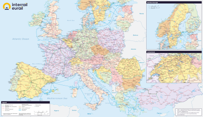
The Interrail Map
So you want to get your plans on the way and start preparing the details of your awesome Interrail adventure ahead? Here's how to find out more:
The Interrail Map
The Interrail Map shows major cities, train and ferry connections as well as journey times between the most popular Interrail destinations to help you plan your journey easily.
How can I get the Interrail Map?
The Interrail Map is now digital and can be accessed as follows...
Interrail mPass holders:
Can access the Interrail Map when they download the Rail Planner App from which they will use their mPass barcode as they travel.
Interrail Paper Pass holders:
Can download the Interrail Map from the link below or access it on the go alongside other important information for Paper Pass users on the Rail Planner App (Please note a paper copy of the Interrail Travel Guide and Map are no longer sent out with orders.)
Click here or on the image below to download your map now!
